Tuesday, February 8, 2011

Interesting Igneous Image (I^3) #2: Bishop Tuff

To prime me for more thesis writing, I hereby bring you the second installment of my Interesting Igneous Image series.


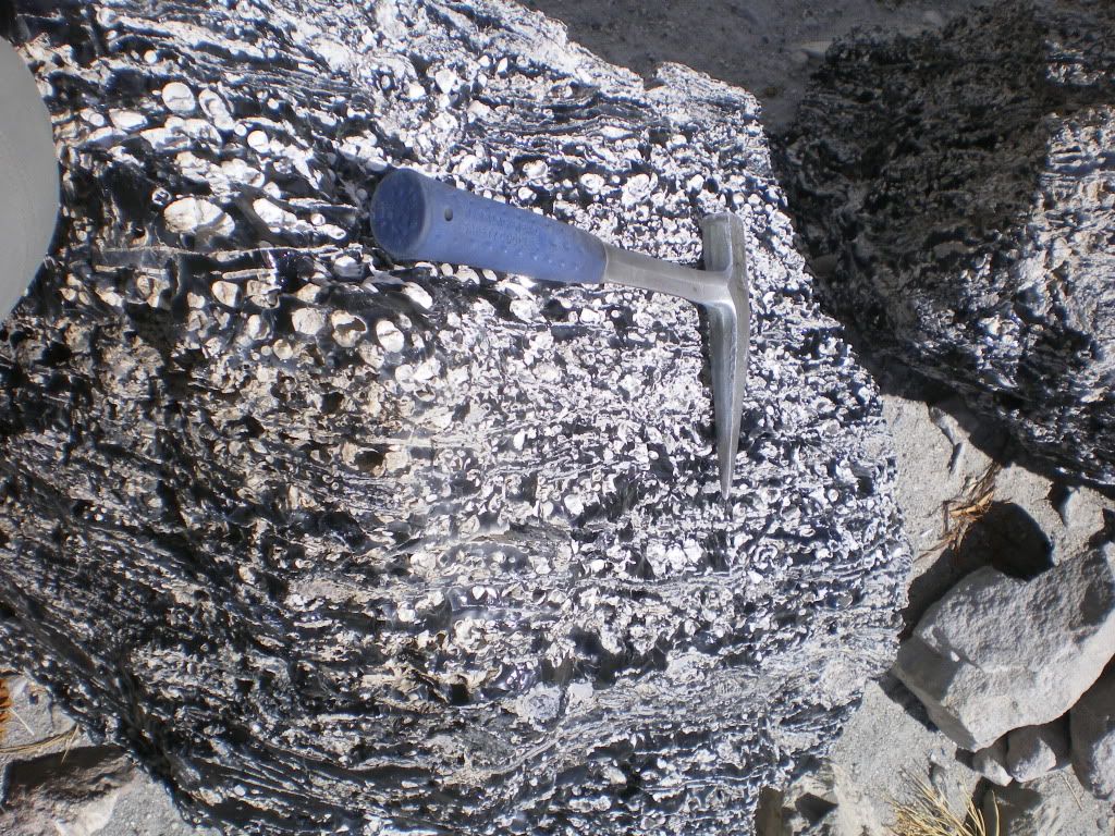
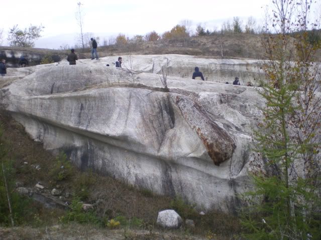
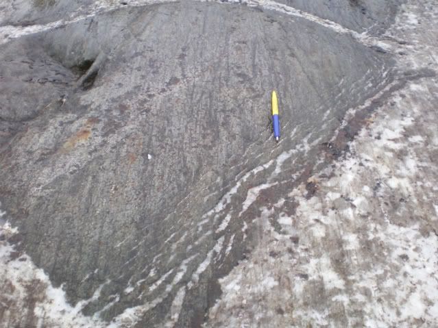
This particular photo is of the densly-welded facies of the ~760 ka Bishop Tuff in the Owens River Gorge. Coin for scale. The stretched wispy dark-grey domains are collapsed pumice, sometimes called "fiamme," Italian for "flame." Fiamme occur when pressure from above and insulating heat within an advancing pyroclastic flow work to collapse the fragile bubble-walls of pumice fragments. Sometimes pyroclastic flow deposits display evidence of rheomorphic behaviour. A "rheomorphic tuff" can be found in the interior of some pyroclastic flows and are a result of being able to flow like coherent lava after being initially deposited as a hot, turbulent incoherent mixture of clasts, pumice and ash.   


Here are some links relating to the Bishop Tuff (2 blogs and two research articles).

NOVA Geoblog, by Callan Bentley

Rhyolitic Magma Based on Melt and Magnetite Inclusions and Zoned Phenocrysts (Journal of Petrology article by Anderson et al., 1999)

Columns: Not just for basalt anymore  Eruptions blog post by Erik Klemetti  

Ring-fracture eruption of the Bishop Tuff  (GSA Bulletin article by Hildreth and Mahood, 1986)  


Enjoy and post remarks if you wish!

~Cole


Above photo (c) 2010 by Cole Kingsbury
   

Friday, January 28, 2011

Where on (Google) Earth -WoGE #260

Many thanks go to Brian Romans of Clastic Detritus for starting this game four years ago!

WoGE #259 was fairly straightforward considering I took a glacial and periglacial geology course during my udergraduate education at the University of Alaska Fairbanks. As a gradutate of an arctic university, I was exposed constantly to the elements of periglacial geology including thermokarst features and thaw ponds. Thus, I am quite famillar with arctic geology and geography. All I really had to do was find a piece of arctic coastline that was smooth and NE-facing. Luckly, WoGE #259 was on my side of the globe (where I started my search).   

As victor of WoGE #259 the torch is hereby passed, and I get to set up the next challenge in "WoGE Wonderland." Thus, here's WoGE #260. Veterans know the rules, but for newcomers, here is how the game is played:

  1. Analyze the screen-capture (at the bottom of this post), and see if you can find where it is by using Google Earth.
  2. Write your answer as a comment to this post describing (a) the location (lat-long and/or specific locality) and (b) a sentence or two about the geology depicted in the image.
  3. The first person to correctly identify specific local and general geology of the image gets to host WoGE #261 on their geoblog – or create a geoblog and then host WoGE #261.
Because much of the globe is in weekend-mode and me feeling quite generous, the Schott Rule is dispensed with for this round. This means veterans and newcomers can immediately dive in to solve this puzzle. Though this rould will probably be solved in relative short order, I will add a hint if this isn’t solved in a couple of days.


Figure for WoGE #260. Click on image for a larger version.


Happy hunting, and have a great weekend!

~Cole K.

Thursday, January 27, 2011

The interview CNN should have given (but didn’t)

The geobloggosphere is currently abuzz over an interview of Dr. Michio Kaku, a highly respected physicist, during a taping of CNN's American Morning show. The subject matter is the Yellowstone Caldera, the likelihood of a super-eruption at Yellowstone in the future and the societal effects should it erupt in our lifetime.  Dr. Erik Klemetti and Gareth Fabbro, both geologists, make eloquent statements in their geoblogs regarding the nature and content of the interview. I am not going to rehash what transpired other than to say CNN has gravely mis-served the public interest by casting a physicist as an expert in geological processes.

Probably one of the most well-respected geologists when it comes to the geology of the Yellowstone Caldera and its eruptions is Dr. Jake Lowenstern, Scientist-in-Charge at the Yellowstone Volcano Observatory. What follows is an interview he gave a couple of years ago and touches on many of the different aspects regarding Yellowstone including eruptive history, hazards, the geothermal system, and the YVO itself. Sure it’s not as dramatic or attention-grabbing as the CNN interview was, but it’s the content that counts, not the drama behind it.


 Yes! Yellowstone is a Volcano (1 of 3)


 The Yellowstone Volcano Observatory (2 of 3)
 

 Yellowstone Eruptions (3 of 3)


All three videos are from "ocweb," USGS's first Youtube channel prior to its move here..


Friday, January 21, 2011

Interesting Igneous Image (I^3) #1

Inspired by fellow geoblogger Brian Romans (of Clastic Detritus) who provides impeccable examples of geology in his Friday Field Photo series, I plan to post one image weekly that I think illustrates interesting igneous geological processes and products. Thus, I kick off my Interesting Igneous Image series with my inaugural image:

   
This image was taken near a pumice mine on the eastern flanks of the Mono Craters chain near June Lake, California. It is of an obsidian chocked-full of spherulites. Spherulites consist of radiating fibres of K-feldspar and quartz (or a high-T polymorph) from a nucleus. This particular rock contains spherulites which have underwent varying degrees of deformation, suggesting a complex relationship between spherulite growth and deformation. Some sphrulites are stretched to the point that they even define flow bands! For more information on the technical details as to how spherulites form, Lofgren (1971) provides an interesting read.

Have a great weekend everyone!

Reference
Lofgren, G. (1971), Spherulitic Textures in Glassy and Crystalline Rocks, J. Geophys. Res., 76(23), 5635–5648, doi:10.1029/JB076i023p05635.  

Photo above (c) 2010 by Cole Kingsbury

Friday, January 14, 2011

Where on Google Earth v0.25K (i.e. #250)!

Hello Geo-enthusiasts!

I hereby present to all of you Where on Google Earth (WoGE) #250. That means we are a quarter of the way to WoGE #1,000! Will we get there? No one really knows – I sure hope we do! If the past rate of WoGE challenges holds in the future, we should be solving WoGE #1k on or about the year 2023. Many thanks go to Brian Romans of Clastic Detritus for starting this game four years ago!

WoGE #249 looked tricky at first, and I thought for a moment that it was somewhere east of Los Angeles, but then I noticed that agricultural fields on the valley floor are not consistent with North American practices in reference to property boundaries. Also the general structural “grain” for much of North America (sans Alaska) is broadly north-south. So I focused my energies elsewhere. In all actuality, WoGE #249 would have been solved much sooner had I done more than a once-over of the North Anatolian Fault Zone. D’OH!

As victor of WoGE #249 the torch is hereby passed, and I get to set up the next challenge in the WoGE conga-line-of-fun. Thus, I am pleased to offer WoGE #250. Veterans of this game know the rules, but for the benefits of newcomers to WoGE, here is how the game is played:

  1. Analyze the screen-capture (at the bottom of this post), and see if you can find where it is by using Google Earth.
  2. Write your answer as a comment to this post describing (a) the location (lat-long and/or specific locality) and (b) a sentence or two about the geology depicted in the image.
  3. The first person to correctly identify location and general geology of the image gets to host WoGE #251 on their geoblog – or create a geoblog and then host WoGE #251.

Since this round is more challenging than the last one I did (WoGE #245) of Plymouth, Montserrat (I think), the  Schott Rule is dispensed with for this round. This means veterans and newcomers can immediately dive in to solve this problem. I will add a hint if this isn’t solved in a couple of days.


Figure in association with WoGE #250: Click on this image to see a larger version.

 
Happy Searching, and happy weekend!


 ~Cole K.


Thursday, December 30, 2010

Where on Google Earth-- New Year's Eve ed. (also #245)

Hello readers and happy new year!

Welcome to “Where on Google Earth" (WoGE for short). WoGE was started by Brian Romans (then blogging as “…or Something” and now as Clastic Detritus) in January of 2007 and is now close to entering its fourth year of geological adventure – virtually at least. I had fun with WoGE #244 as it was an adventure down the East African Rift. Coupled with the hint given by fellow geoblogger Andrew Alden (over at about.com), I raced over to eastern Africa, followed the rift valley north to south until I got to Lake Malombe with its sine-curve-shaped west shore. As a newcomer to this game myself, WoGE has allowed me to travel the virtual globe to parts that I probably would not have been to otherwise. Yeah, I'm busted! 


As victor of WoGE #244 the torch is hereby passed to me, and I get to set up the next WoGE challenge. Thus, I am pleased to offer WoGE #245. Veterans of this game know the rules, but for the benefit of newcomers to WoGE, here is how the game is played:

  1. Analyze the screen-capture (at the bottom of this post), and see if you can find where it is by using Google Earth.
  2. Write a comment to this post describing (a) the location (lat-long and/or specific locality) and (b) a sentence or two about the geology depicted in the image.
  3. The first person to correctly identify location and general geology of the image gets to host WoGE #246 on their geoblog – or create a geoblog and then host WoGE #246. Extra kudos if this challenge is solved before the year runs out!

Since this is a fairly straightforward challenge despite the small area pictured (I think), and to allow for WoGE newcomers a chance to get into the action, the Schott Rule is hereby invoked. Under this rule, previous winners must wait one hour after the contest starts to answer. 


 Figure for WoGE # 245. Click to see a larger verson. This may be the first WoGE challenge using Google Earth v.6

Good luck, happy new year, and I'll see you in 2011! :-)


Posted on December 31st at 9:05 AM PST

Tuesday, December 21, 2010

End of Semester Wrap-up


Greetings readers!

After a couple of weeks or so taking care of wrapping up the fall semester, I have embarked on winter vacation in my other home near Portland, Oregon --Whew!. While my thesis field area is in the eastern Sierras of California, I think its time that I post some geologically noteworthy photographs in the area where I spend most of my time, in the National Capital Region of Canada. These photographs were taken on fieldtrips as a part of an introductory geology course that I was honoured to serve as a teaching assistant.


Glacially-carved “rat-tail” near the Cantley Quarry, north of Gatineau, Quebec. A relatively resistant xenolith within less resistant marble (both of Grenville affinity) provides good information regarding the trajectory of glacial ice movement from the Laurentide Ice Sheet. In this photo, the ice moved right-to-left.


Glacial striations in both the xenolith and the enclosing marble from the Cantley Quarry. The right-margin of the xenolith resembles “slicken-fibres.” Unsure if it was from the glaciations or from the Grenville orogeney (thoughts?) Yellow-part of the pen points in the direction from where the ice flowed.


Photo showing an unconformity between the Precambrian Grenville gneiss, below and the Paleozoic Nepean Sandstone above nearby. The gneiss is ~1 Ga (billion years old) whereas the Nepean sandstone is ~500 Ma (million years old). Thus, about a half-billion years of earth history in the Ottawa Valley is missing. Photo was taken beside a road in Parc Lac Beauchamp in Gatineau, Quebec.

Have a great holiday!

All photos (c) by Cole Kingsbury