Sunday, July 12, 2015

Where on Google Earth v.0.5k (WoGE #500)!

My long dormant blog has come back to life! 

Welcome to the 500th contest of Where on Google Earth (WoGE)! This is the game where we combine our collective love of geology with our obsession (or at least love) with Google Earth(R).

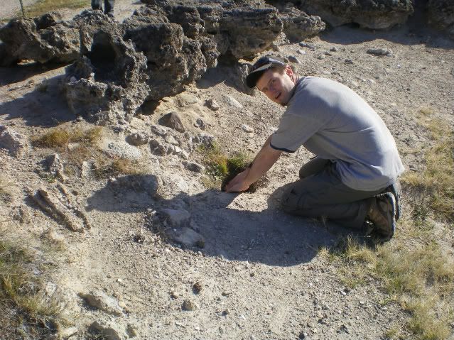
In searching the location for WoGE 499, I heavily relied on the presence of centre-pivot irrigation circles to guide me since only small parts of the globe have these present. Initially I searched North American examples, but nearly everywhere I have found, had these laid out in the familiar square closest-packing arrangement that is a byproduct of the prevailing North American land use system. The arrangement of the centre-pivot irrigation system used in Felix’s contest #499 however, are hexagonal closest-packed. I still remember my packing arrangements! So that led me initially to the Atacama Desert in South America, but unsuccessful with that, quickly moved to northern Saharan Africa then on down to South Africa where I found the Barkly West locality by following a river. I basically played “desert centre-pivot tag.”

Moving on to my challenge to the WoGE community: This 500th rendition of WoGE does not have the benefit of centre-pivot irrigation circles, but nonetheless does have the benefit of some cool geology. Please locate on Google Earth(R) the following mystery featured in Figure 1.  Rules and specifics after the jump.

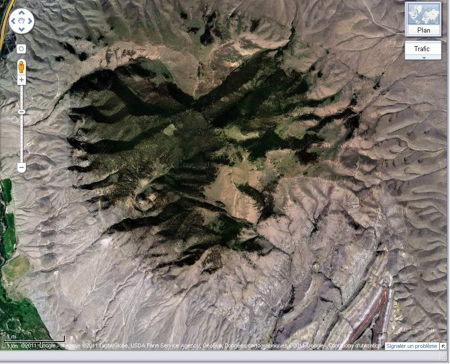
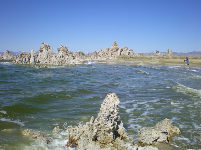
Figure 1: WoGE #500 entry. Where is this and what is its geology? Note the north arrow at the bottom-right.


Veterans of this game know what to do, but for the benefit of newcomers, the basic premise (detailed here) is that a screenshot or image derived from Google Earth is posted by the winner of the previous round and your task is to find “Where (precisely) on Google Earth” the image is from. Once you find it, you put in the comments section the specific location and a brief synopsis of its geology and/or geologic significance.

Specifically, to win this round: please post, in the comments section below, the following information:

  1.  Location, in either:
    1. Lat-Long; or
    2. Distance and bearing from any nearby ( <30 km) labeled towns or outposts, including province, state or territory information; or
    3. Geographic name of feature and what province, state or territory its located in.
  2. A brief synopsis of the geology of what is shown. This may require some cursory fact-finding on the internet.

The first person who answers correctly is the lucky winner of this round! As a prize, the winner gets:

  1.  Immense satisfaction that they have earned their place in WoGE history by winning WoGE #500; and
  2. Gets to host WoGE #501 on their blog or ask someone if they can guest-host WoGE #501 on their blog; then
  3. Post a link to their WoGE #501 challenge -- once ready -- in the comments section of this post to maintain the chain of links.
For this round, sensing this WoGE contest will be particularly popular due to it being the 500th, I am invoking the “Schott Rule (SR)”, which means those who have won at least one of the past 499 WoGE contests must wait one hour after "posting time,"shown below, to give those who have not won or those who are new a fighting chance.

If there is no winning response within a few days, I will post a hint in this space. 

Good luck . . . happy Google Earth-ing . . . and I hope all your weekends are going good! :-)

Prosper!

~Cole K.

Posting time:  July 12th 2015   09:00 PDT    12:00 EDT    16:00 UTC    17:00 BST    18:00 CET


SR Expires:   July 12th 2015    10:00 PDT    13:00 EDT    17:00 UTC    18:00 BST    19:00 CET

Friday, January 18, 2013

"Ten Hundred Words of Science": my research in simple English


Hi Readers!

Jumping on a very long caravan of bandwagons, I thought I would introduce the subject of my PhD project using only words from the 1000 most commonly-used words in the English language (try it for yourself using the Up-Goer 5 text box!) Many members of the geoblogosphere, myself inspired by Professor Anne Jefferson's post, have contributed their job descriptions and study subjects using only the 1000 most common used words in English. A Tumblr page entitled “Ten Hundred Words of Science” created by Anne Jefferson and Chris Rowan aggregates meme submissions quite nicely and was an eye opener for me.

Because I study Large Igneous Provinces (LIPs) in general and the High Arctic LIP in specific, doing so was quite the challenge. Words like “mantle “ and “plume” as well as “igneous” and “province” along with “analyze” and “geochemistry’ are not allowed for this meme exercise. I had quite the challenge in front of me as a result, but participating in this meme has actually forced me to think about how to explain my subject matter without using highly technical jargon we in the geosciences utter within the discipline. A necessity when trying to explain what I do to interested laypersons. So without further adieu, here is my job description and PhD topic using only the 1000 most common words:


Using the means of people who study people who have done very bad things, I study a big hot thing of rock that came deep under foot a long time ago and went off big, a lot of times during a short time. Other large hot thing of rock that came deep under foot and went off killed animals, changed things and may have helped us live. 

My area of study is in a very cold place at the top of the big round rock we live on. Its one of the least understood area of rocks formed by a large hot thing of rock that came deep under foot. Using the things I learn, I then tell people about it during talks and writing papers.

As Paul Harvey would say: "and now you know . . . the rest of the story"!

Have a good weekend!

~Cole K.

cc #upgoer5

Sunday, December 18, 2011

Carbonatite lavas of Ol Doinyo Lengai --with the actual movies this time!

I  Finally figured out how to embed YouTube clips! The original version only showed complicated html coding, so I deleted that. Now back to the show:

Hello readers!

A short (I have exams to proctor and grade) blog update to post some cool YouTube fottage of Ol Doinyo Lengai in Tanzania Africa and its unique eruptions of caronatite lavas. Whereas 99.9% of of lavas that are issued worldwide is modeled based upon the silica [SiO4] tetrahedra, carbonatite is principally composed of carbonate minerals. Dawson and others (1990) documented abundant phenocrysts of the rare alkali carbonate minerals nyerereite an gregoryite while noting the conspicuous absences of any major silica phase during the November 1998 activity. The temperature of these lavas are quite low during effusion: less than 600°C, (Dawson et al., 1990)!

Enough of mew talking: click on the film clips below and try to convince yourself that you are seeing competent lavas and NOT muds oozing, flowing or burping out of the volcano!

Small roiling lava pond:


Carbonatite lava channel:


Carbonatite spattering:


Reference:

Dawson, J.B., Pinkerton, G.E., Norton, G.E., Pyle, D.M., 1990. Physiochemical properties of alkali carbonatite lavas: Data from the 1988 eruption of  Oldoinyo Lengai Tanzania: Geology, 18, pp. 260-263

Saturday, December 10, 2011

Accretionary Wedge #41: My response

Im Back!


Ron Schott over at Geology Home Companion is hosting the 41st round of the Accretionary Wedge, where he wants participants to describe the most memorable geologic event that one has experienced. What follows is my contribution:

For my grade 10 Social Studies class, one of the requirements thereof was to write a paper about some culture. I chose to write about the Maori people of New Zealand. One class period was reserved to work on the report in the computer lab while the teacher roamed around, in case students needed help. I, on the computer just as you walk inside the lab and a hare to the right, asked the teacher to come over for help with ideas as I was experiencing writer's block. We had a great discussion and bounced ideas off each other for several minutes, when it happened.

What happened, exactly? The setting was a high school in Beaverton, OR (a southwestern suburb of Portland) on the afternoon of February 28th, 2001. If the date and location sound sort of familiar, I am referring to the M6.8 Nisqually Earthquake that struck the Pacific Northwest. The hypocentre of the earthquake according to the Pacific Northwest Seismic Network's data page, was situated 52 km at depth with the associated epicentre ~18 km NE of Olympia.

This earthquake was my first earthquake I have felt in my life at that point and so for the first few seconds, I wasn't sure what was going on. The ground started rolling like broad waves and confusion amongst my fellow students and the faculty present in the computer lab was quite evident. The earthquake itself lasted, I venture, 15-30 seconds and fits most closely to a III or IV on the Modified Mercalli Intensity scale where I was located at the time.

A few second's after the shaking stopped, the Principal of the school along with the campus safety person stepped foot in the computer lab and announced "May I have your attention? For your information, yes we did experience an earthquake. Please duck and cover," or something to that effect. What occurred soon after the duck-and-cover exercise I cannot recall, but I do believe we were let out of school early and in my case went home and  watched the news reports on the damage to the Puget Sound area while talking to my parental units about our collective experiences. An event I will never forget.

~Cole G. Kingsbury                  

Thursday, May 19, 2011

First Pics from the Field

 Hi Readers!


Well after a few days of resting following a 15 day whirlwind geology field excursion around eastern California and Nevada, (with a fleetng stop in Arizona) here are some pics I have taken. This first batch largely focuses on the Mono Basin and Long Valley of eastern California. We were going to stop at Obsidian Dome to look at "my baby" but nearby Mammoth Mountain recieved 600 inches of snow this winter, apparently double the usual amount according to the person that does reservations in Mammoth Lakes. Mammoth Mountain was mantled with thick snow cover and skiers were still carving crisp turns on the slopes. Needless to say, Obsidian Dome, (and the road leading to it) was still coloured white. In late April. I was scheduled to do my  talk regarding the geology of Obsidian Dome in front of my travel mates while on Obsidian Dome, but Panum Crater had to suffice as an imposter. How do you spell "dang"?


That said and done, here are some pictures from the first couple of days on the trip, Map for geographic reference:

The famous tufa spires on the south shore of Mono Lake, California

Large spherulite in Obsidian from the Glass Mountains (NE margin of Long Valley Caldera)
Nice reverse fault cutting the distal, non-welded Bishop Tuff exposed at an abandoned pumice quarry just north of Bishop.
Nice photo showing densly welded, more proximal facies of the Bishop Tuff exposed in the Owens River Gorge. Note the nice wisps of flattened pumice, or "fiamme."This was slightly overhanging so, in order to show scale, I faintly denoted 1 cm to the lower left of the large angular lithic clast, near the centre of the image.
View of the Hot Creek Geological Area. Ahhh the sight of hot springs and fumeroles and the sweet smell of volcanic perfume is a nice way to end a day of geotripping. :-)
Yours truly warming his hands in "Handwarming Fumerole." Informally named by me thanks to the nice handwarming qualities of this particular fumerole. The temperature outdoors was kind of nippy at the time, but not too bad. Handwarming Fumerole was far from scalding in temperature.
Hope you enjoyed these photos, and I'll post a second batch in the next few days.

Untill nxet time: Prosper geologically!

~Cole K.

Above photos (c) 2011 by Cole Kingsbury

Thursday, April 21, 2011

Getting ready for a geological adventure

Hello readers!

Its been quite some time since I have posted to my Chaotically flow banded blog so I think its time for an update:

Tomorrow, I will be departing Ottawa, Ontario for the deserts of the American southwest to partcipate in a 15-day advanced field studies course offered by Carleton University (I am one of only two University of Ottawa Students attending this trip). This field couse will examine the many volcanic and structual features which make Nevada and adjacent parts of California scenery so spectacular. What follows is a brief outline of where the field course will be headed

  • 23 April:           Meet in Reno, Nevada
  • 24-26 April-:    Mammoth Lakes area to examine Long Valley caldera and Mono basisn
  • 27 April           Enroute to Beatty, NV, look at Big Pine volcanic field andDeath Valley geology
  • 28 April           Spend entire day analyzing the geology around the Yucca Mountain, NV area and discuss nuclear storage implications. Sojourn in Boulder City, NV for 3 nights. 
  • 29 April:          Look at the Searchlight Pluton near Searchlight, NV (South of Las Vegas)
  • 30 April:          Tectonism of the Basin and Range-Colorado Plateau transition near Lake Mead, NV/AZ.
  • 01 May:          Tour Hoover Dam. Drive to Lo$t Wage$ for a day off -- where your's truly will NOT touch a slot machine!
  • 02 May:          Back to geology. Drive north towards Austin, NV, stopping at the Tonopah Mining Museum. Stay 1 night in Austin, NV.
  • 03 May:          Examine the tilted Tertiary Caetano Caldera in Lander County, NV. Stay in Battle Mountan, NV, (so-called the "Armpit of the Nation" by the Washington Post) for 3 nights.
  • 04 May:          Volcanology of the Fish Creek Mountains caldera and the Buffalo Valley volcanic field.
  • 05 May:          Basin and Range tectonism around Battle Mountain
  • 06 May:          Drive Back to Reno for the inevitable end of the field trip.


Nearly all packed and ready to go! Included, but are not going back to their homeland are two samples of Bishop Tuff which are nicely camouflaged with the carpet.

One Aspect I am particularly looking forward to is going back to Obsidian Dome which is the subject of my thesis. I have become so attached to that dome during my initial field work that I have nicknamed it "my baby." I am scheduled to make a presentation to the trip participants on the emplacement history and structural controls which influence the location of Obsidian Dome.       

I will try to post pseudo-daily updates to this blog, as well as an image taken during time in the field that day. Free wi-fi at the various hotels and motels helps matters greatly!

I am psyched!

~Cole G. Kingsbury

Above photo (c) 2011 by Cole Kingsbury

Monday, February 14, 2011

My Geo-Valentine's Day blogCard

Greetings readers!


From my road-side outcrop to yours, I wish all of my geoscience friends and bloggers a happy Valentine's Day. A Valentine's Day geologically speaking cannot be without displaying a screen-shot of the McCartney Mountain area of Beaverhead county, Montana from Google Maps.

Screen-shot from Google Maps

Again, happy Valentine's Day to all, and to all a pleasant day!

~Cole K