
Many thanks go to Brian Romans of Clastic Detritus for starting this game four years ago!
WoGE #259 was fairly straightforward considering I took a glacial and periglacial geology course during my udergraduate education at the University of Alaska Fairbanks. As a gradutate of an arctic university, I was exposed constantly to the elements of periglacial geology including thermokarst features and thaw ponds. Thus, I am quite famillar with arctic geology and geography. All I really had to do was find a piece of arctic coastline that was smooth and NE-facing. Luckly, WoGE #259 was on my side of the globe (where I started my search).
As victor of WoGE #259 the torch is hereby passed, and I get to set up the next challenge in "WoGE Wonderland." Thus, here's WoGE #260. Veterans know the rules, but for newcomers, here is how the game is played:
- Analyze the screen-capture (at the bottom of this post), and see if you can find where it is by using Google Earth.
- Write your answer as a comment to this post describing (a) the location (lat-long and/or specific locality) and (b) a sentence or two about the geology depicted in the image.
- The first person to correctly identify specific local and general geology of the image gets to host WoGE #261 on their geoblog – or create a geoblog and then host WoGE #261.
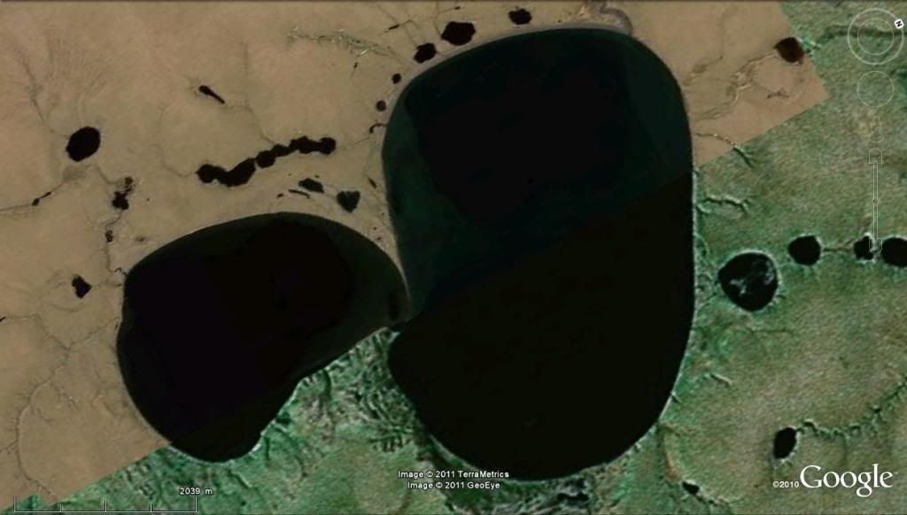
Figure for WoGE #260. Click on image for a larger version.
Happy hunting, and have a great weekend!
~Cole K.
66.3933N, 164.4940W
ReplyDeleteTwo of the larger thermokarst lakes on the northern Seward Peninsula, western Alaska.
I don't have much firsthand experience with recent periglacial environments, so that's about as much as I can tell you about these, other than pointing to the Wikipedia article on the phenomenon: Thermokarst
Hey Ron!
ReplyDeleteWelcome back to the fold. I thought you dropped off!
Anyways, location is correct and if we stretch the definition of "thermokarst" greatly, you would also be correct. The lake pictured is Devil's Mountian Lake. It may seem strange, but this lake is actually a maar -- the largest maar on the planet. Here is some interesting background: http://www2.gi.alaska.edu/ScienceForum/ASF17/1785.html. Jim Beget who is quoted here was my undergrad research adviser and instructor for 4 classes I took (incl glacial and periglacial).
Anyways you have WoGE #261 (and a bunch of updating to do on that WoGE kml file) :)
Maar-velous! Makes a lot more sense as a volcanic vent at this size than a thermokarst feature. No indication of that when you look at it in Google Earth, though. Seems to have eluded the Smithsonian volcanoes list (and the associated GE volcanoes layer).
ReplyDeleteWoGE #261 is posted. Schott Rule invoked.
ReplyDelete