
Hello Geo-enthusiasts!
I hereby present to all of you Where on Google Earth (WoGE) #250. That means we are a quarter of the way to WoGE #1,000! Will we get there? No one really knows – I sure hope we do! If the past rate of WoGE challenges holds in the future, we should be solving WoGE #1k on or about the year 2023. Many thanks go to Brian Romans of Clastic Detritus for starting this game four years ago!
WoGE #249 looked tricky at first, and I thought for a moment that it was somewhere east of Los Angeles, but then I noticed that agricultural fields on the valley floor are not consistent with North American practices in reference to property boundaries. Also the general structural “grain” for much of North America (sans Alaska) is broadly north-south. So I focused my energies elsewhere. In all actuality, WoGE #249 would have been solved much sooner had I done more than a once-over of the North Anatolian Fault Zone. D’OH!
As victor of WoGE #249 the torch is hereby passed, and I get to set up the next challenge in the WoGE conga-line-of-fun. Thus, I am pleased to offer WoGE #250. Veterans of this game know the rules, but for the benefits of newcomers to WoGE, here is how the game is played:
- Analyze the screen-capture (at the bottom of this post), and see if you can find where it is by using Google Earth.
- Write your answer as a comment to this post describing (a) the location (lat-long and/or specific locality) and (b) a sentence or two about the geology depicted in the image.
- The first person to correctly identify location and general geology of the image gets to host WoGE #251 on their geoblog – or create a geoblog and then host WoGE #251.
Since this round is more challenging than the last one I did (WoGE #245) of Plymouth, Montserrat (I think), the Schott Rule is dispensed with for this round. This means veterans and newcomers can immediately dive in to solve this problem. I will add a hint if this isn’t solved in a couple of days.
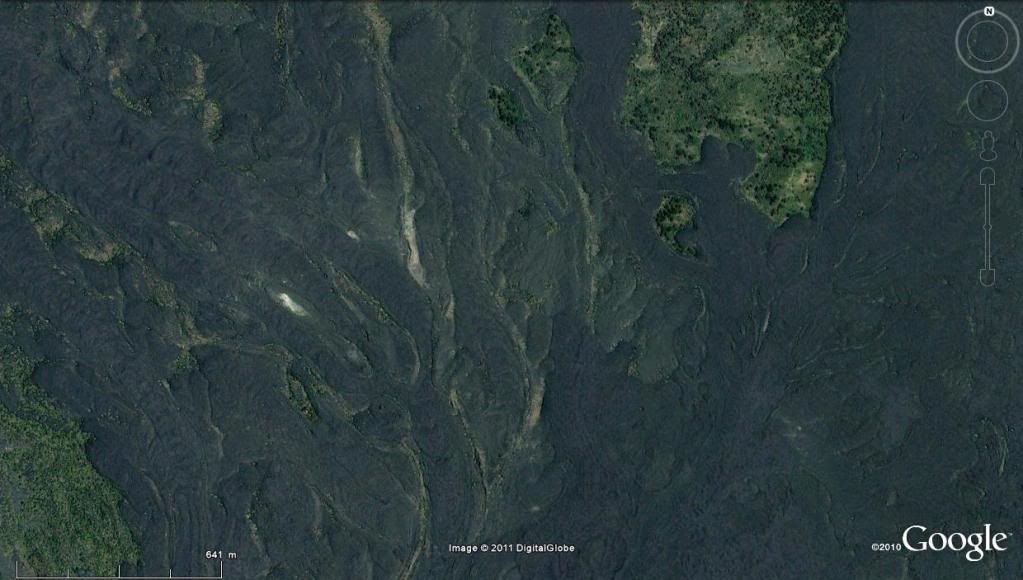
Figure in association with WoGE #250: Click on this image to see a larger version.
Happy Searching, and happy weekend!
~Cole K.
Volcano Paricutin, 19°31'N 102°14'W
ReplyDeleteThe volcano began as a fissure in a cornfield on February 20, 1943. The volcano grew quickly, reaching five stories tall in just a week, and it could be seen from afar in a month. Much of the volcano's growth occurred during its first year.
Nice location. I've read about "Pulido's" volcano before, but I've never seen it before.
Bling bling bling we have a winner! Excellent job Felix! I was worried that it might not have been that distinguishable from other youthful flows around the world. In fact, I was seriously thinking about capturing a close-up of the partially buried church instead. Glad I have been proven wrong!
ReplyDeleteI hereby pass the torch to you, and WoGE #251 is all yours!
~Cole K :-)
WOGE251 is online.
ReplyDelete