Friday, January 28, 2011

Where on (Google) Earth -WoGE #260

Many thanks go to Brian Romans of Clastic Detritus for starting this game four years ago!

WoGE #259 was fairly straightforward considering I took a glacial and periglacial geology course during my udergraduate education at the University of Alaska Fairbanks. As a gradutate of an arctic university, I was exposed constantly to the elements of periglacial geology including thermokarst features and thaw ponds. Thus, I am quite famillar with arctic geology and geography. All I really had to do was find a piece of arctic coastline that was smooth and NE-facing. Luckly, WoGE #259 was on my side of the globe (where I started my search).   

As victor of WoGE #259 the torch is hereby passed, and I get to set up the next challenge in "WoGE Wonderland." Thus, here's WoGE #260. Veterans know the rules, but for newcomers, here is how the game is played:

  1. Analyze the screen-capture (at the bottom of this post), and see if you can find where it is by using Google Earth.
  2. Write your answer as a comment to this post describing (a) the location (lat-long and/or specific locality) and (b) a sentence or two about the geology depicted in the image.
  3. The first person to correctly identify specific local and general geology of the image gets to host WoGE #261 on their geoblog – or create a geoblog and then host WoGE #261.
Because much of the globe is in weekend-mode and me feeling quite generous, the Schott Rule is dispensed with for this round. This means veterans and newcomers can immediately dive in to solve this puzzle. Though this rould will probably be solved in relative short order, I will add a hint if this isn’t solved in a couple of days.


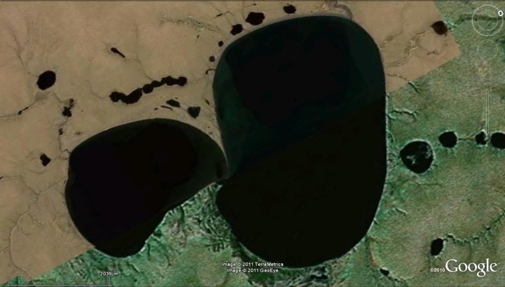
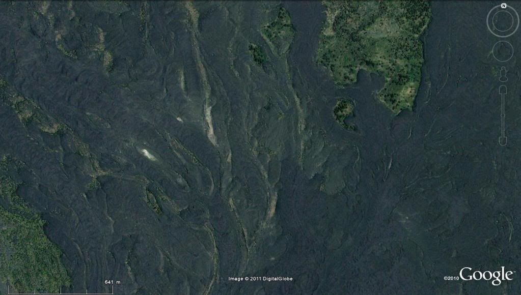
Figure for WoGE #260. Click on image for a larger version.


Happy hunting, and have a great weekend!

~Cole K.

Thursday, January 27, 2011

The interview CNN should have given (but didn’t)

The geobloggosphere is currently abuzz over an interview of Dr. Michio Kaku, a highly respected physicist, during a taping of CNN's American Morning show. The subject matter is the Yellowstone Caldera, the likelihood of a super-eruption at Yellowstone in the future and the societal effects should it erupt in our lifetime.  Dr. Erik Klemetti and Gareth Fabbro, both geologists, make eloquent statements in their geoblogs regarding the nature and content of the interview. I am not going to rehash what transpired other than to say CNN has gravely mis-served the public interest by casting a physicist as an expert in geological processes.

Probably one of the most well-respected geologists when it comes to the geology of the Yellowstone Caldera and its eruptions is Dr. Jake Lowenstern, Scientist-in-Charge at the Yellowstone Volcano Observatory. What follows is an interview he gave a couple of years ago and touches on many of the different aspects regarding Yellowstone including eruptive history, hazards, the geothermal system, and the YVO itself. Sure it’s not as dramatic or attention-grabbing as the CNN interview was, but it’s the content that counts, not the drama behind it.


 Yes! Yellowstone is a Volcano (1 of 3)


 The Yellowstone Volcano Observatory (2 of 3)
 

 Yellowstone Eruptions (3 of 3)


All three videos are from "ocweb," USGS's first Youtube channel prior to its move here..


Friday, January 21, 2011

Interesting Igneous Image (I^3) #1

Inspired by fellow geoblogger Brian Romans (of Clastic Detritus) who provides impeccable examples of geology in his Friday Field Photo series, I plan to post one image weekly that I think illustrates interesting igneous geological processes and products. Thus, I kick off my Interesting Igneous Image series with my inaugural image:

   
This image was taken near a pumice mine on the eastern flanks of the Mono Craters chain near June Lake, California. It is of an obsidian chocked-full of spherulites. Spherulites consist of radiating fibres of K-feldspar and quartz (or a high-T polymorph) from a nucleus. This particular rock contains spherulites which have underwent varying degrees of deformation, suggesting a complex relationship between spherulite growth and deformation. Some sphrulites are stretched to the point that they even define flow bands! For more information on the technical details as to how spherulites form, Lofgren (1971) provides an interesting read.

Have a great weekend everyone!

Reference
Lofgren, G. (1971), Spherulitic Textures in Glassy and Crystalline Rocks, J. Geophys. Res., 76(23), 5635–5648, doi:10.1029/JB076i023p05635.  

Photo above (c) 2010 by Cole Kingsbury

Friday, January 14, 2011

Where on Google Earth v0.25K (i.e. #250)!

Hello Geo-enthusiasts!

I hereby present to all of you Where on Google Earth (WoGE) #250. That means we are a quarter of the way to WoGE #1,000! Will we get there? No one really knows – I sure hope we do! If the past rate of WoGE challenges holds in the future, we should be solving WoGE #1k on or about the year 2023. Many thanks go to Brian Romans of Clastic Detritus for starting this game four years ago!

WoGE #249 looked tricky at first, and I thought for a moment that it was somewhere east of Los Angeles, but then I noticed that agricultural fields on the valley floor are not consistent with North American practices in reference to property boundaries. Also the general structural “grain” for much of North America (sans Alaska) is broadly north-south. So I focused my energies elsewhere. In all actuality, WoGE #249 would have been solved much sooner had I done more than a once-over of the North Anatolian Fault Zone. D’OH!

As victor of WoGE #249 the torch is hereby passed, and I get to set up the next challenge in the WoGE conga-line-of-fun. Thus, I am pleased to offer WoGE #250. Veterans of this game know the rules, but for the benefits of newcomers to WoGE, here is how the game is played:

  1. Analyze the screen-capture (at the bottom of this post), and see if you can find where it is by using Google Earth.
  2. Write your answer as a comment to this post describing (a) the location (lat-long and/or specific locality) and (b) a sentence or two about the geology depicted in the image.
  3. The first person to correctly identify location and general geology of the image gets to host WoGE #251 on their geoblog – or create a geoblog and then host WoGE #251.

Since this round is more challenging than the last one I did (WoGE #245) of Plymouth, Montserrat (I think), the  Schott Rule is dispensed with for this round. This means veterans and newcomers can immediately dive in to solve this problem. I will add a hint if this isn’t solved in a couple of days.


Figure in association with WoGE #250: Click on this image to see a larger version.

 
Happy Searching, and happy weekend!


 ~Cole K.